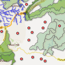
MultiGeometry MultiGeometry
The MultiGeometry layer is used to display KML data. It can be used to represent points, lines and polygons.
Clicking on any of the features on the map will show all the data associated with the spatial feature KML attributes.
Polygons and lines are taken from KML file uploads and these features are stored as a MapProvision dataset.
Points in a KML layer can be taken from either CSV or KML uploads.
Once there you can navigate to:
Visualize > Map > Configure Styles
To change how the MultiGeometry layer's points, lines and polygons are displayed.
|